CBM has prepared responses to FAQs that were raised during the virtual public meetings and other consultation completed for the proposed project to date. The FAQs have been grouped by topic.
CBM is in the process of updating the FAQ responses from questions received during the Public Meeting held by the Town of Caledon under the Planning Act in June 2023 and the virtual meeting held by CBM in October 2023 for the purposes of the licence application under the Aggregate Resources Act. The FAQs will update in the coming weeks to address the questions received at the sessions.
1. Who is CBM Aggregates?
CBM Aggregates is a leading supplier of stone, sand and gravel that is used to support new construction, modernization, infrastructure development and improvements vital to the economic health, well-being and growth of Ontario.
CBM Aggregates safely operates nearly 60 licences for pits and quarries in Ontario. As part of St. Marys Cement Inc. (Canada), founded in 1912, CBM Aggregates has a long history of working closely with communities to minimize the influence of our operations, manage environmental effects and maximize our positive contribution to the communities in which we operate. St. Marys Cement’s concrete division, CBM, also supplies ready-mixed concrete for major projects and award-winning structures, including the CN tower.
Canada Building Materials’ (CBM), concrete and aggregate divisions, and St Marys Cement Inc. (Canada) are all part of the North American operations of international building materials supplier, Votorantim Cimentos. More information can be found at www.canadabuildingmaterials.com.
2. Is CBM affiliated with the Osprey Valley Golf Course?
No. Pro-M Capital Partners Inc., a private equity firm, owns Osprey Valley Golf Course, and some of the proposed project lands. CBM is leasing some of the lands from Pro-M Capital for the proposed Project.
3. What is CBM proposing?
CBM is exploring the opportunity of developing a quarry in the vicinity of Charleston Sideroad and Main Street/Regional Road 136 in the Town of Caledon. CBM commenced the exploratory process and initiated field work and multiple studies starting in February 2020, which have been assisting us in understanding the feasibility for extraction before applications are submitted for consideration to the province and the municipalities (Peel Region and Town of Caledon) under the Aggregate Resources Act and Planning Act, respectively.
4. What is the size of the proposed quarry?
The size of the proposed quarry has been determined using the results of the technical studies that are nearing completion for the proposed Project. The location of the quarry is within the area identified as the ‘Licence Area’ that would be applied for under the Aggregate Resources Act (ARA).
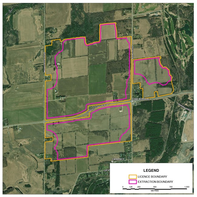
Currently, the proposed ‘Licence Area’ would be approximately 262.4 hectares, and contains not only the extraction area but any area that is required for setback and land that may be needed for supporting works and activities.
The proposed Project ‘Extraction Area’ is currently estimated to be approximately 204.9 hectares.
Please see the answer to question 6 below for further information and definitions.
5. What would the extracted aggregate be used for?
Primarily, the extracted aggregate would be used to make high-quality gravel-sized products that are required for the production of high-strength concrete. In addition to this, the resource at this site would be expected to produce aggregate used for the construction of roads, houses, bridges, and hospitals. The limestone would not be used for cement powder as it does not have the appropriate chemical properties.
In Ontario, approximately 160-170 Million tonnes of aggregate are used annually. The anticipated population increase in Peel Region, including the Town of Caledon, will require a close to market source of high-quality aggregate. The limestone extracted from the Project site would be used to fulfill local needs.
Having high-quality aggregate close to market is important in order to reduce aggregate costs, as well as truck travel and associated air emissions.
6. What area is CBM studying and why hasn’t a quarry footprint been established yet?
As mentioned in answer 4, the ultimate extent of the proposed quarry has been determined using the results of the technical studies nearing completion for the proposed Project. It is important to understand a few terms that help explain how the assessment is carried out to the point of defining an extraction area. The illustration below shows the steps to defining a proposed extraction footprint.
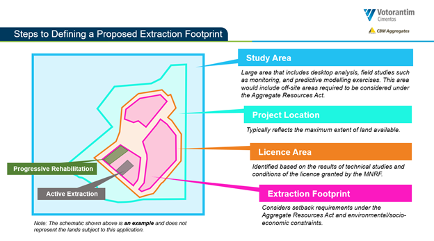
These terms are further described below:
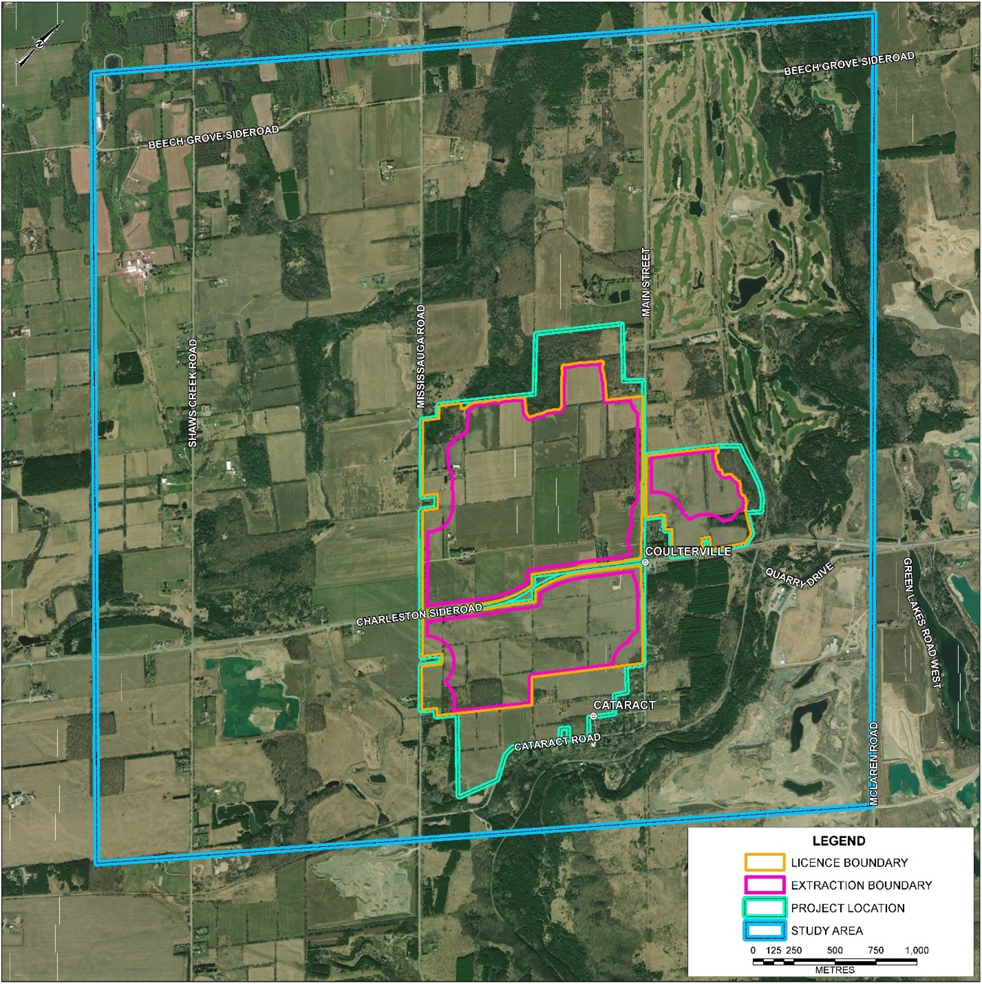
- Study Area: The Study Area is the total area that is being assessed and studied through analysis and field studies such as monitoring, and predictive modelling exercises. For a more comprehensive study, this area includes both off-site areas required to be considered under the Aggregate Resources Act and also areas that make sense to include from a more thorough impact assessment standpoint, depending on the technical study being completed. Assessments/studies are being completed within the overall Study Area to understand the existing conditions and create a ‘baseline’ understanding of the various environs in and around the Licence Area. The extent of the Study Area varies depending on the technical study but is large enough so that it encompasses a ‘sub-watershed upwards to a watershed’ type scale and also captures potential cumulative effects with other existing projects and activities that may be located nearby.
- Project Location: The Project Location area reflects the maximum extent of land that is within CBM’s control to consider the proposed Project. The total Project Location area, or lands within CBM’s control, totals approximately 324 hectares.
- Licence Area: The Licence Area is the area that would ultimately be applied for under the Aggregate Resources Act and contains not only the extraction area but any area that is required for setbacks and land that may be needed for supporting works and activities, such as the construction of berms. The area, as first applied for, is identified based on the results of the technical studies but could ultimately be refined through the review and approval process and would have conditions placed on it by the Ministry of Natural Resources and Forestry (MNRF). The Licence Area is estimated to be 262.4 hectares.
- Extraction Area: The Extraction Area is the maximum area where active extraction would occur. The extraction area considers setback requirements under the Aggregate Resources Act and environmental/socio-economic constraints. Within the Extraction Area there would be an ‘active’ area where extraction would take place. This ‘active’ area is much smaller than the overall Extraction Area and Licence Area that would be depicted on the proposed Site Plans since actual extraction would be conducted in designated areas and move to different areas of the site over time, followed by Progressive Rehabilitation. The Extraction Area wis estimated to be approximately 204.9 hectares.
- Active Extraction Area : The Active Extraction Area is the area where extraction is taking place at any given time. Typically, different ‘Phases’ are identified on a Site Plan (issued by the NDMNRF) that show which phase extraction will be taking place. Restriction is placed on the operation with respect to how many ‘Phases’ can be open at the same time. This is also a mechanism for the NDMNRF to ensure that Progressive Rehabilitation is taking place.
- Progressive Rehabilitation: Progressive Rehabilitation takes place in areas of the site where full extraction has been completed and rehabilitation efforts, such as side slopes, can take place. The purpose of Progressive Rehabilitation is to make sure that an operator does not leave all of the rehabilitation obligations to the end of the operation of the site. This is enforced by the MNRF through rehabilitation ‘orders’ if an operator has not completed sufficient Progressive Rehabilitation in comparison to the area that has been extracted.
- The Licence Area and proposed Extraction Footprint are yet to be defined and would be set back from the Project Location boundary.
- A map showing the specific Licence Area and Extraction Area is provided below.
*See definitions of Study Area, Project Location, Licence Area and Extraction Area above.
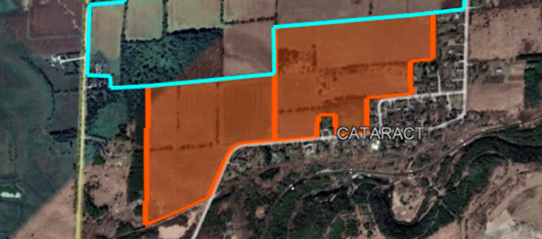
7. Is the Project Location subject to change?
The Project Location represents the current landholdings being considered for the Project; however, it is possible for this to change. For instance, CBM announced during the December 2021 virtual public information session that they would be excluding the southernmost 35 hectares (88 acres) of land (outlined and shaded in orange in the figure below) from any future licence application, and for the entirety of the life of any potential quarry that may be approved. This reduced the extent of the Project Location area from approximately 324 hectares to approximately 289 hectares. It is more important to note that the Licence Area and Extraction Area, which are located within the Project Location area, have been defined based on ongoing studies and would form smaller areas.
8. What is the status of the licence application?
CBM is currently completing the technical studies to support a licence application that would be submitted to the MNRF. These studies commenced in February 2020, and almost three years of studies will have been completed before an Aggregate Resources Act application is submitted to MNRF for review. Currently CBM’s anticipated timing for submission is towards the end of 2022. Note that the Aggregate Resources Act and Planning Act applications, including the supporting technical reports and plans, would be circulated to the relevant departments at the Town and Region, as well as other external agencies including the Credit Valley Conservation Authority (CVC) and the Ministry of Environment, Conservation and Parks (MECP). These agencies often subject the technical reports to third party peer reviewers, and CBM would be responsible for the cost associated with any third-party reviews.
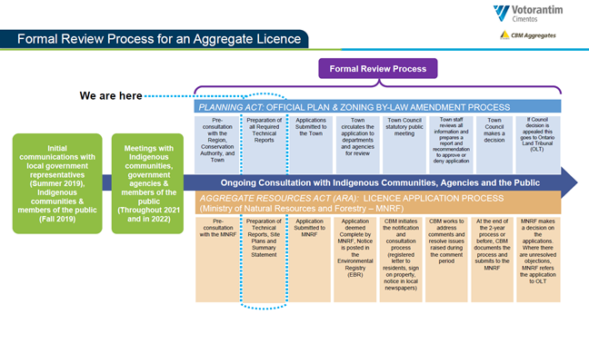
9. What is the timeline of the proposed Project?
Almost three years of technical studies will have been completed before applications are submitted to the MNRF and the municipality for consideration. It is anticipated that the review of the applications by the MNRF, the Town of Caledon and other government agencies would take a number of review cycles before a licence decision is made. There will be multiple opportunities for consultation and engagement throughout the process, before and after the initial submission of the application. A depiction of the process is outlined below. Comments and questions can be sent to CBMCaledonQuarry@golder.com or directly to CBM at any time (please refer to the end of this FAQ document for CBM contact information).
10. How many years do you expect the proposed quarry would be in operation?
The proposed tonnage limit for the quarry is a maximum of 2.5 million tonnes per year, and all studies have assumed this maximum tonnage extraction scenario.
Despite the maximum permitted tonnage limit, on average CBM would anticipate extracting approximately 2 million tonnes per year; however, this would be dependent on market conditions. Based on this the project life would be over 40 years. The permanent processing facility would be expected to be installed north of Charleston Sideroad approximately 5 years after start of operations. Extraction would be expected to extend across Main Street to the east, approximately 10 years after the start of operations. Extraction south of Charleston Sideroad would not be anticipated to commence until approximately 30 years after the start of operations.
11. What would be the expected hours of operation of the proposed quarry?
The results from the technical studies will help determine the hours of operation of the proposed quarry. Once the technical studies have been completed the proposed hours of operation will be provided.
12. What is the current zoning of the Project Location and would a zoning amendment be required for the proposed Project?
The Project is currently predominantly within the Region of Peel’s High Potential Mineral Aggregate Resource Area” (HPMARA) and the Town of Caledon’s “Caledon High Potential Mineral Aggregate Area” (CHPMARA). These delineations are mapped in the Regional and Town Official Plans and represent lands which contain primary and secondary sand and gravel resource areas and selected bedrock resource areas. An Official Plan Amendment to the Town of Caledon’s Official Plan would be required to redesignate the proposed Licence Area lands to an Extractive Industrial land use designation to facilitate the proposed aggregate operation.
The current zoning of the Project Location is predominantly “A-1, Agricultural”. As such, construction and operation of the project in this location would require a zoning amendment. Under the Planning Act, an amendment to the zoning by-law as well as the Town of Caledon’s Official Plan would be required to put in place the necessary land use permissions, which would permit the aggregate operation. The Town of Caledon is the approval authority; however, the application and supporting technical documentation would be reviewed by the Region of Peel and other regulatory agencies. The Planning Act approvals would have to be in place before a licence is obtained under the Aggregate Resources Act.
13. Would the proposed Project require blasting? How often would blasting be required for operation of the quarry?
Yes. Blasting would be required for extraction of the limestone resource, but not the sand and gravel resource that is located on top of the limestone in certain parts of the site. The frequency and duration of the blasts that would be required for the proposed Project will be determined by the technical studies being completed. Based on other CBM sites, it is anticipated that blasting would occur once or twice a week, depending on the thickness of the resource in different parts of the site, conducted during daytime hours and each blast event would be expected to last approximately two seconds.
Federal and provincial regulations in Canada ensure that blasting activities are safe and controlled. Further details on blasting activities and associated mitigation measures can be found in questions 14, 45, 46, 47, 48, 49, 50 and 54.
14. What is the proposed setback for the aggregate extraction and blasting activities?
The Aggregate Resources Act Regulation requires specific minimum setbacks depending on the land use and zoning surrounding the Licence Area:
- 15 metres (approximately 50 feet) from any part of the boundary of the Licence Area (i.e., next to other land designated as agricultural for instance).
- The 15m setback is increased to 30 metres (approximately 100 feet) from any part of the boundary of the Licence Area that is adjacent to a road/highway, land that is used for residential, or land that is restricted to residential use by a zoning by-law.
- 30 metres (approximately 100 feet) from any body of water that is not the result of excavation below the water table.
The setbacks for the Project have been determined as a result of the technical studies and not just the minimums required by the Regulations. The Project-specific setbacks are based on the results of the technical studies such as noise, vibration/blasting, air quality and hydrogeology, and the requirements of applicable legislation with respect to the results of these studies (e.g., requirements from the MECP with respect to noise limits at sensitive receptors and air quality standards and criteria). CBM has also incorporated the concerns raised by the public in determining the ultimate proposed setbacks for the project.
As such, more restrictive setbacks have been applied in the design of the extraction boundary including 150 m from all residential receptors.
15. Would the aggregate extraction occur below the water table?
Yes. CBM is proposing to conduct aggregate extraction below the water table. The majority of the limestone deposit is below the water table and, as such, would require extraction to occur below the water table.
16. Would the proposed Project require dewatering?
Based on the current understanding of the Project and knowledge of the hydrogeology in the area, CBM expects that some dewatering would be required. As part of the application the impacts of dewatering will be assessed, including a detailed evaluation of any potential for influence on domestic wells and the surrounding environment. More about the hydrogeology considerations is included in the Groundwater section of these FAQs.
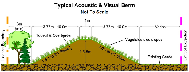
17. Would berms be installed between the proposed quarry and the surrounding properties?
CBM proposes that berms (e.g., berms made out of topsoil stripped in preparation for aggregate extraction and then seeded, or vegetated) would be constructed for the purposes of the Project and the benefit of the community. The location and height of the berms will be determined by the results of the technical studies, such as the noise study.
It is anticipated that the majority of the berms would offset from the property boundary by 3 metres, and would be 5 metres in height with a 2:1 (horizontal: vertical) slope. Along the top of the berms would be a 1 to 2 metre wide crest. It is anticipated that the berms would be composed of topsoil from the site.
A schematic of what a potential berm would look like is provided below, please note this schematic is not to scale and does not have the same measurements as outlined above:
18. How can CBM guarantee that they will be in compliance with the conditions of the licence, if one is granted for the Project?
If an Aggregate Resources Act licence is granted for the project, CBM will be required by law to operate in accordance with the provisions of the Aggregate Resources Act licence and site plan. These documents include all of the recommendations from the detailed technical reports completed for the project and other conditions to ensure compliance with the requirements of the Aggregate Resources Act.
Aggregate licences are subject to an annual compliance assessment report and annual monitoring reports that are submitted to the applicable government agency to demonstrate compliance with the conditions of approval. MNRF has the authority to conduct random inspections of sites and if a complaint is received they complete an investigation to ensure the site is in compliance with the required operating conditions. If CBM does not operate in accordance with the provisions of the Aggregate Resources Act approval MNRF has the legislative authority to issue an order, suspend or revoke the licence.
Also see response to 29 regarding annual monitoring requirements and proposed Public Liaison Committee.
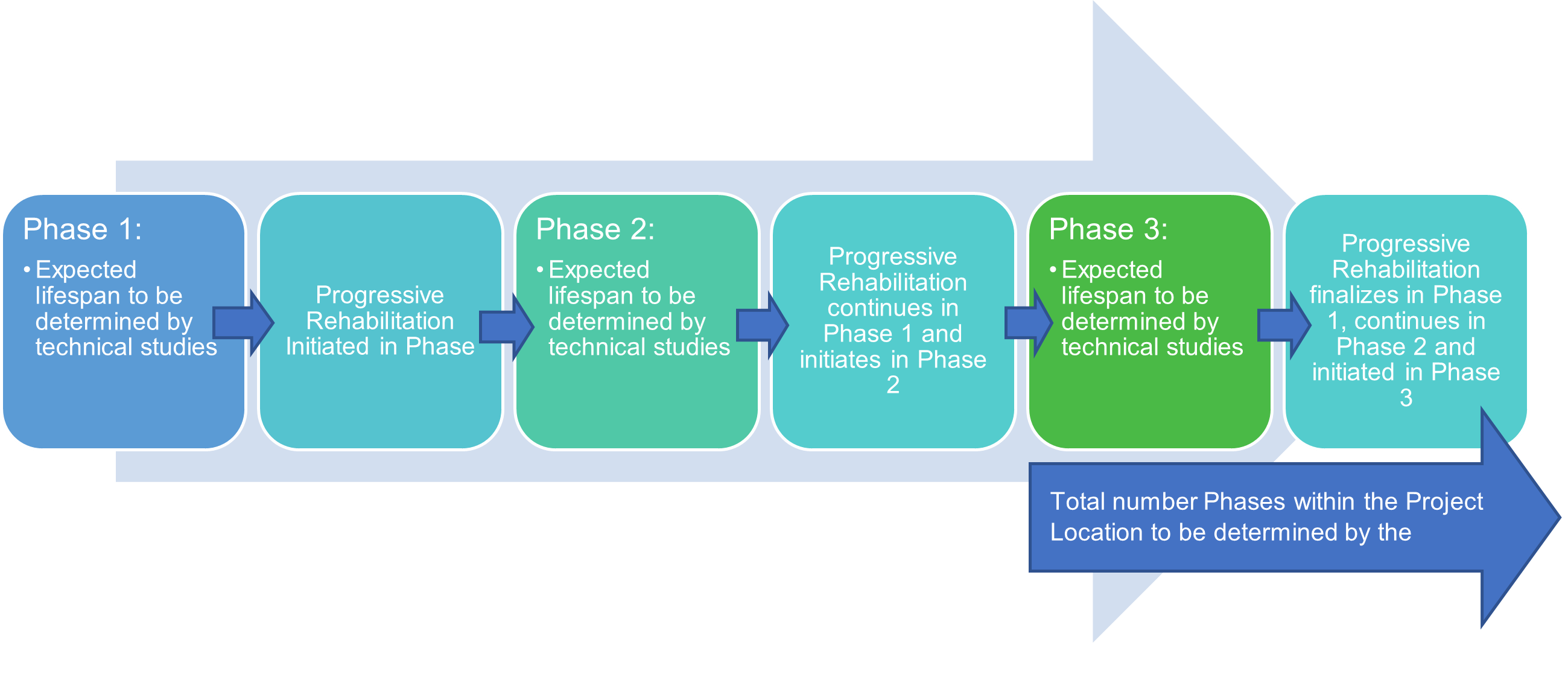
19.Would there be multiple and concurrent active extraction sites within the Licence Area?
It is anticipated that within the extraction footprint of the Project there may be different points of active extraction needed for blending purposes, but that these would typically be located in the same general area of the site (i.e., an identified ‘Phase’ on the Site Plan). It is possible that sand and gravel extraction may occur in a different area, or Phase, than the limestone extraction, depending on where the sand and gravel is located. Each phase of extraction would be operating for several years and undergo progressive rehabilitation once full extraction has taken place. A general depiction of this is provided in the flow chart below. The total number of Phases within the Licence Area is defined by the technical studies, and currently approximately 7 phases are anticipated. This means that at any given time, the area of active extraction would be small relative to the overall Licence Area. These anticipated phases and the approximate location of the permanent processing facility are shown in the figure further below.
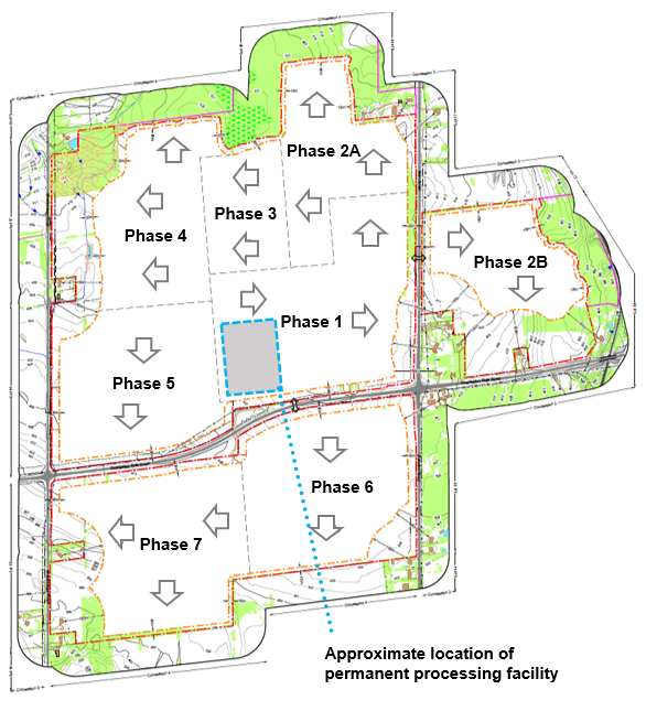
20. Where does CBM anticipate extraction would commence for the proposed Project?
If a licence is granted, CBM anticipates that aggregate extraction, of both sand and gravel and limestone resources, would commence north of Charleston Sideroad and west of Main Street/east of Mississauga Road. It is currently anticipated that extraction of limestone would only continue south of Charleston Sideroad once limestone reserves are exhausted north of Charleston Sideroad. It is anticipated that it will be approximately 30 years before extraction would start to occur south of Charleston Sideroad.
21. How deep would the proposed quarry be? What is the depth and thickness of the limestone that would be extracted?
The bedrock unit that has been identified as a primary resource is the Gasport (former known as Amabel) Formation. Based on available information gathered from the site investigations, it is understood that this formation is approximately 8 to 27 metres thick (thickness varies throughout the Licence Area). The depth of the proposed quarry would reflect the thickness of this formation.
The depth of the groundwater table varies across the Licence Area depending on the topography of the land, and in certain areas is a few metres below ground surface. The depth of the groundwater table across the Licence Area will be incorporated into the technical studies being completed.
22. Where would the aggregate be processed?
If a licence is granted, the aggregate would be processed on-site within the extraction footprint. Once the overburden has been removed at a portion of the site, the overburden would be placed in on-site berms. Portable processing equipment would be located on the bedrock surface until some of the limestone resource has been extracted. Once a sufficient area of limestone has been extracted, a more permanent plant would be constructed below grade in the extracted area in order to help with noise mitigation. This is currently being proposed north of Charleston Sideroad, approximately midway between Mississauga Road and Main Street (see figure included in question and answer #19 above).
23. When will the technical studies take place?
The technical studies have been ongoing since February 2020 and will continue through to the end of 2022.
24. Who is conducting the technical studies?
CBM has retained the services of engineering and environmental experts, Golder Associates Ltd. for the resource and environmental technical studies, (including: archaeology, cultural heritage, noise, blasting, air quality, natural environment, water, visual and socio-economics), Colville Consulting Inc. for an agricultural impact assessment, Glen Schnarr & Associates Inc. and MHBC Planning for the land use planning amendments and supporting reports including Site Plans, T.Y. Lin International Canada Inc. (TYLin, formerly TMIG) for traffic studies. Each of these firms are leading experts in their fields.
25. Will the technical studies be shared with the public?
CBM has been conducting virtual open houses for surrounding residents as draft findings from the technical report are made available. On September 07, 2022 a session was held that reviewed the potential extraction area, and results from the traffic, noise, blasting, and air studies. CBM is also planning a session in November to review water, natural environment and visual impact. Once the reports are filed with the MNRF and the Town of Caledon and circulated to the relevant departments at the Town and the Region of Peel, as well as other external agencies including the CVC and the MECPas part of the application process, copies of the technical studies will also be posted to the project website for the public to review.
26. Is CBM addressing the cumulative effects of this proposed Project with other projects in the area?
Yes. As part of the technical studies, CBM is considering other existing projects in the area and how they are interacting with elements of the environment, such as water quality and quantity, traffic, air quality, and noise.
27. What are the potential environmental impacts of the Project?
An assessment of the potential effects of the Project on the environment is ongoing as part of the technical studies. These studies are being completed to ensure that no significant impacts are realized on the environment or surrounding community as a result of the Project. The findings of the effects assessment will be shared with the community prior to technical reports being finalized.
28. What mitigation measures would CBM implement to reduce the impacts of the proposed Project?
The technical studies will ultimately determine if and what mitigation measures would need to be implemented by CBM to minimize impacts of the Project on the environment and surrounding community. These proposed mitigation measures will be based on the recommendations of the various technical reports and will be incorporated into the proposed Aggregate Resources Act site plans. Typical mitigation measures for a quarry include, but are not limited to, incorporation of appropriate setbacks, avoidance of sensitive features, installation of berms around the extraction area to minimize noise and visual impacts, implementation of a dust management plan, site specific blast design, scheduled hours of operation, and overall design of the quarry operation to minimize impacts.
29. What type of environmental monitoring would continue for the proposed quarry, if a licence is granted?
Should a licence be granted, monitoring will be a condition of the licence for the entire duration of the extraction and rehabilitation of the site.
The technical studies will determine the types of environmental monitoring that would be completed throughout the life of the Project. Permitting requirements outside of the licence application will also have monitoring requirements. At a minimum, CBM would be conducting (through a third-party consultant) water resource monitoring (groundwater and surface water), noise and blasting monitoring. These third-party consultants would prepare annual reports outlining the results of the environmental monitoring and would provide the reports to the relevant agencies for review. CBM would also make the reports available through the Project website. If a licence is granted, CBM also anticipates that a Public Liaison Committee (PLC) would be formed in order to keep the public informed on a continual basis, including review of any ongoing monitoring reports that would be generated. If members of the public have questions related to the monitoring results, CBM would coordinate with the third-party consultant to provide answers to queries raised.
30. What is the expected volume of water that would be pumped from quarry operations?
The hydrogeology technical study will determine the volume of water that would require pumping as part of the quarry operations. It is important to note that water would be recycled on-site where possible and, while large volumes of water may be handled as part of the operation, pumped water would not be consumed and would still be available to the watershed. Comprehensive groundwater/surface water modelling is currently being completed to determine the volume of water that would require pumping from quarry operations and the best discharge location for the pumped water.
31. How would dewatering water be managed for the proposed Project?
The approach to management of the pumped water will be determined through the results of the technical studies. Water that would be pumped through dewatering may be discharged into the local environment (e.g., Credit River) in order to keep the water within the local watershed, or it may be recycled for use in washing aggregate products during the operation of the quarry. Any pumping of water on-site would require a Permit To Take Water from the MECP. For any water discharged back into the environment, discharge locations would be identified through the technical studies. The discharged water would have to meet strict water quality criteria, and any discharge would require an Environmental Compliance Approval from the MECP.
32. What are potential impacts of dewatering?
An assessment of the potential effects of dewatering is being completed as part of the water resources technical study, to ensure that no significant impacts are realized on surrounding land uses (including water supplies) and the environment as a result of the Project. Dewatering will create a groundwater drawdown zone (zone of influence) from the quarry. This predicted zone of influence is being assessed in relation to how it may affect the surrounding environs. The findings of the water resource technical study will be shared with the community prior to the technical report being finalized.
33. What mitigation measures would CBM implement to reduce the potential impacts of dewatering?
The hydrogeology technical study will determine the mitigation measures that may need to be implemented by CBM to reduce impacts of dewatering. If any mitigation measures are required, they will be shared with the community prior to technical reports being finalized.
34. Are you working to determine if domestic and commercial water wells may be impacted?
An assessment of the potential effects of dewatering on water supplies in the area is being completed as part of the hydrogeology technical study, to ensure that no adverse impacts are realized as a result of the Project. CBM is committed to ensure people’s water supplies are available to them and, further, it is required under the Aggregate Resources Act and the Ontario Water Resources Act that any future operations will have no noticeable or adverse effects on well water quality or quantity. A domestic well survey was completed by CBM to help gather information on surrounding domestic and commercial wells that will help to predict and monitor potential effects of the Project on those wells. CBM and its consulting team went door-to-door within a 1-kilometre (km) radius of the Project Location in July 2021 to hand deliver an information package and well questionnaire, and speak with neighbours regarding the water well survey. The well survey allows well-specific information to be gathered by CBM about the domestic and commercial wells in the area so that it can be included in our technical studies.
If you have a well and live in proximity to the proposed project (i.e., within 1 km), are interested in participating in this survey, and did not receive the original hand-delivered request, or have questions about the survey and the benefits of participating in this survey, please contact us at CBMCaledonQuarry@golder.com.
35. In the event of impacts to private wells, how would CBM compensate private well owners?
First and foremost, CBM must ensure domestic and commercial water supply will not be adversely impacted. The detailed technical studies will evaluate the potential for a water supply to be affected and will identify potential mitigation that can take place before a licence is granted or potential effect is observed. However, to protect citizens, in cases where wells are impacted by the Project, the Ontario Water Resources Act requires that any operation that has created an impact must provide the impacted well owners an alternate potable water source (e.g., water well deepening, provide a new water well location etc.).
36. What are the potential impacts on the significant natural environment features and the Credit River?
An assessment of the potential effects of the Project on the natural environment and the Credit River is being completed as part of the technical studies. The studies are being undertaken to ensure that no negative impacts are realized to any key natural environment feature, including the Credit River, as a result of the Project. The findings of the effects assessment will be shared with the community prior to technical reports being finalized.
37. Will there be any impacts to the provincially significant wetland identified during the baseline studies?
An assessment of the potential effects of the Project on significant natural environment features is being completed as part of the technical studies. The provincially significant wetland is not located within the proposed extraction area and a setback will be established based on the recommendations of the technical studies to ensure the there are no negative impacts to the wetland.
38. What would the expected truck traffic activity be as a result of the proposed Project? Would trucks run 24 hours a day?
The number of trucks that would be used is correlated with the amount of aggregate that would be extracted on an annual basis as determined by the technical studies. Based on the current operations plan, an annual maximum extraction limit of 2.5 million tonnes will generate an estimated maximum of 78 total new two-way truck trips during the a.m. peak hours of July, the typical highest haulage month of activity for quarries. Shipping from aggregate sites typically does not occur 24 hours per day. There may be rare occasions where specific government projects, for example, require shipment of products during atypical hours to accommodate construction requirements. However, for this to take place, special permission would be required from the MNRF and the municipality if outside of the shipping hours listed in the site plan. On the rare occasions that this may occur, restricted noise limits would have to be met during those windows.
39. What is the expected haul route that CBM would use for the proposed Project?
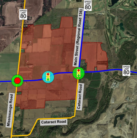
Charleston Sideroad is an already-established haul route and it is anticipated that this would be the primary haul route for the Project, where aggregate products would be shipped via truck primarily to the east along Charleston Sideroad and then south on Highway 10 towards the GTA, with minor local deliveries using other approved haul routes in the area. CBM anticipates that entry and exit to the quarry would be directly onto Charleston Sideroad.
The figure below identifies the preferred location of the Charleston Sideroad signalized access central to the proposed quarry between Mississauga Road and Main Street.
40. Will road improvements be required at Charleston Sideroad to support the Project?
Road improvements required to support Project operations (e.g., deceleration lanes, road signals) will be identified by the technical studies, and CBM would be responsible for obtaining the appropriate approvals and associated implementation and cost of these improvements.
41. Will CBM complete additional baseline traffic counts seeing as those completed for the Project (as of 2021) were completed during the COVID-19 pandemic, and are therefore not representative of normal local traffic conditions?
Traffic counts completed in 2020/2021 will be complemented with historical traffic counts. In addition, CBM completed additional traffic counts during spring 2022. CBM is also consulting with the Town of Caledon and the Region of Peel regarding potential future developments in the area that may affect traffic counts in the future.
42. Will the effects of truck idling be assessed by CBM?
As part of the application, CBM will design the site to ensure that trucks have sufficient room to queue on-site to avoid trucks parking and idling on surrounding roads.
43. Would CBM support a bypass around the village of Caledon to access Highway 10?
CBM does not own or control any land that would be required for a bypass around the Village of Caledon to access Highway 10. CBM recognizes that the proposed bypass would involve a number of different landowners and if it came to fruition years of study and approvals would be required. If this initiative is pursued CBM would be happy to support and participate in this initiative.
44. Does the Traffic Study consider projected increases in the growth of the local community and traffic on the local roads as a result?
Yes. The study incorporates projected increases in traffic based on annual growth rate information gathered from the Town, Region and MTO.
45. Can you provide an example as to how loud the blasting may be?
Noise levels associated with blasting activities are regulated and must be kept within thresholds established by the MECP, however, it largely depends on how far the “receptor” is from the blasting activity. Based on noise generated during blasting at other CBM quarry sites, and in consideration of required setbacks at those sites, the noise generated from blasting activities at residences nearby to those sites is the equivalent to hearing a jackhammer in the distance. Blasts, however, are very short (approximately two seconds) and, if a licence is granted, it is anticipated that blasting would occur only one to two times per week.
46. What mitigation measures would CBM implement to reduce the risk of wild flyrock (i.e., flyrock leaving the quarry site) during blasting activities?
Potential flyrock resulting from quarry operations is a serious offense in Ontario, and could result in heavy fines, the suspension of an operating licence, and/or prosecution if damage and/or injury were to occur. CBM takes this risk very seriously and operates their quarries in a way that prevents the risk of flyrock. Flyrock is not permitted to leave the licensed site and each blast will include a detailed design to prevent such an incident from happening. Flyrock has been modelled and this modelling has confirmed that quarry blasting can be carried out without flyrock leaving the licensed site.
47. What mitigation measures would CBM implement to reduce the impact of noise from blasting or general Project activities?
The blasting and noise technical studies will determine the blasting design and mitigation measures that would be implemented by CBM to reduce noise and vibration impacts and meet regulatory requirements. Berms would be installed as part of the Project to minimize effects on ambient noise levels. In addition, CBM is proposing increasing setbacks from neighbouring homes to 150m in order to provide additional separation distance compared to the provincial requirement of 30 m. Other examples of noise mitigation could include:
- Procurement of quieter equipment.
- Restriction of specific operational activities in certain areas.
- Implementation of localized equipment-specific mitigation, such as: enclosures, local barriers, and silencers.
Ongoing compliance ground and air vibrations from blasts will inform the blast designer if, or when, blast design changes may be required to reduce the vibration impacts and meet regulatory requirements.
For instance, blasting when there is a very low cloud ceiling will be avoided whenever operationally possible, as that can contribute to air vibrations propagating further than would typically be the case.
48. Can property damage occur off-site from the cumulative effects of blasting at an adjacent quarry over a long period?
Several studies have been carried out to look at the long-term effects of repeated blasting on structures. These studies conclude that repeated blasting over several decades, producing peak vibration levels well in excess of the provincial guideline limits, were required to cause cosmetic threshold cracking to occur. At levels below MECP limits, there would not be any noticeable cumulative effect associated with the blasting operations from the proposed quarry on nearby residential structures.
49. Are blasting contractors required to be qualified?
Blasts will be designed and reviewed by qualified professional engineers and carried out by experienced, qualified blasting personnel. All blasting contractors must meet the licencing and permitting requirements, including those for purchasing, transporting and storage of explosives.
50. Will explosives be stored on site?
Blasting is carried out by contractors who will temporarily store on site only what is required for use during the day of the blast. There will be no long-term storage of explosives at the site. All required explosives will be transported to site at the beginning of the set up for the given blast from the contractors licenced off-site facility. Any remaining explosives not required for a given blast will be returned to that off-site facility once the blast has been completed.
51. How would noise monitoring be completed for the Project?
Baseline noise monitoring is being completed for the Project and includes the installation of monitoring equipment at four locations across the Project Location, in proximity to sensitive receptors.
If the Project is approved, noise audits would be completed by a third-party consultant to ensure that noise levels during operation are within the regulatory requirements.
52. What mitigation measures would CBM implement to reduce the impact on air quality from Project activities?
The air quality technical study will determine the mitigation measures that would be implemented by CBM to reduce impacts to air quality that could potentially result from the Project. To address comments received during consultation, CBM is also completing a site-specific study to assess if predicted emissions from the proposed quarry (e.g., particulates, crystalline silica) will pose a risk to human health and to identify mitigation measures if they are needed.
CBM will be implementing a dust best management practices plan (BMPP) to minimize dust generation on-site. CBM has also installed air quality monitors to monitor air quality levels in the vicinity of the Project, in order to establish background air quality levels that will be included in the air quality technical study.
53. Will air quality be monitored across a long enough period of time that will account for seasonal changes? Where is the monitoring equipment located?
Yes. The current monitoring location for air quality is on the west side of the proposed Licence Area, north of Charleton Sideroad, to account for the local prevailing wind direction from the west. Monitoring has been ongoing since Fall 2021 and is continuing.
54. Has CBM received complaints associated with blasting, noise or air quality at active aggregate sites, and how has CBM dealt with such complaints?
Yes, CBM has received complaints associated with active sites and takes these complaints very seriously. Once a complaint is made, an investigation is undertaken to understand what happened and the source of the complaint. After a complaint is received, CBM also adjust activities accordingly, where possible, to account for how nearby receptors are perceiving vibration, noise and air emissions, even if emissions are within regulatory requirements.
55. What is CBM’s current carbon footprint?
Sustainability is one of CBM’s parent company pillars and, as a company, CBM strives to be an environmental steward and is aiming towards carbon neutrality. CBM’s parent company is also part of an initiative aiming for carbon neutrality by 2050 for the global cement community. CBM’s rehabilitation efforts across the province also aid in reducing the company’s carbon footprint by offsetting greenhouse gas emissions.
CBM is also completing a carbon footprint study specific to the Project and will share the results with the public once available.
56. Would rehabilitation be completed for the proposed Project?
Yes. CBM is committed to best-in-class rehabilitation and, further, the Aggregate Resources Act requires both progressive and final rehabilitation to be completed as part of a licence. CBM understands the importance of rehabilitation at the properties it owns and operates, and has implemented successful, award winning, rehabilitation at many sites over the years (please visit the Rehabilitation subpage on the Project website for rehabilitation examples). Restoring the land to a similar or enhanced end-use after extraction has taken place is one of the most important goals of the aggregate industry in general, but is a core value for CBM, being part of Votorantim Cimentos, where sustainability is identified as a key business pillar for the company.
57. How would rehabilitation for the proposed Project look?
The rehabilitation for the proposed Project will be determined by the technical studies, with input from the community and government agencies. Plans for rehabilitation will be shared with the community, once available. Given that extraction below the water table would be taking place as part of the operation, it is anticipated that a water feature of some sort would result with a gentle, safe slope to the water’s edge that would be built with backfilled excess soil from the Project site. It is important to consider that this step in the quarry’s lifecycle would take place decades from now, yet it is included as a critical factor in the licensee application and approval process.
The proposed rehabilitation plan for the Project will be outlined in the site plans to be provided as part of the licence application.
58. Please provide examples of past rehabilitation Projects that CBM has completed
Please visit the Rehabilitation subpage on the Project website for several examples of best-in-class rehabilitation that CBM has completed at other sites across the province.
59. What are the potential impacts on property values?
The value of a property is impacted by numerous factors including but not limited to market conditions, upkeep of the property, and surrounding land uses. When assessing the potential impacts of any new development planning policies do not require the consideration of potential impact on property values.
From a planning perspective, the area subject to the application is a protected mineral aggregate area and the Town of Caledon Official Plan anticipates aggregate extraction to occur on the site, subject to minimizing impacts on surrounding residential uses in accordance with provincial standards and guidelines.
CBM recognizes that property values are a concern that has been raised in relation to this Project. To help further mitigate impacts, CBM is including very specific design considerations into the Project that exceed provincial standards in order to protect surrounding residential properties. This includes, but is not limited to, enhanced extraction setbacks of 150 m, whereas provincial standards require a 30 m setback.
60. Would CBM be willing to purchase properties adjacent to the Project site?
Depending on where the property is located and the availability of Capital funds at the time, CBM may be open to the possibility of purchasing of adjacent properties and would evaluate offers from nearby landowners on a case-by-case basis. This, however, is not a common practice, as CBM intends for the site to be designed and operated in a manner that minimizes impacts on the surrounding residents.
61. How would the community benefit from the proposed Project?
Long-term projects such as this have both direct and indirect benefits to the communities in which they are located. Some direct benefits would include job creation, tax benefits, tonnage fees paid to communities through The Ontario Aggregate Resources Corporation (TOARC), and the local use of the extracted aggregate products that help build local communities in Ontario. Indirect benefits would include the spin-off economic benefits and job creation that would be created through the life of the site, through not only the Town but also the Region, and also the potential for future use of the site, depending on the end use that would be created (i.e., a lake), and future accessibility to it.
CBM is completing a socio-economic study for the Project to identify community benefits, as well as to assess the potential effects of the Project on socio-economic environs, such as nuisance effects to residents, tourism and changes in land use (i.e., from agricultural to quarry).
CBM also announced to the public in December 2021 that the southernmost 88 acres of the site would be assessed for potential donation. CBM will be working with the Town and CVC to determine the best end use for those lands (i.e., creating a forested area).
62. How many jobs would be created as a result of the proposed Project?
CBM estimates that, if the site becomes fully operational, approximately 50 to 70 people may be employed directly for the Project, with the number being significantly higher for indirect jobs (e.g., concrete producers, truckers, contractors etc.) over the life of the quarry.
63. Would CBM pay tonnage fees to the Region?
Yes. CBM would pay a levy fee to TOARC, which is responsible for collecting and disbursing aggregate fees to the Town of Caledon and the Region of Peel. The Town and Region could use those funds for various community needs such as road maintenance; however, it is ultimately at their discretion. A full explanation of the TOARC fees and how they are used and distributed can be found at the TOARC website: https://toarc.com/annual-reports/
64. What is CBM's plan for public consultation for the proposed Project?
CBM’s plan for public consultation is to undertake meaningful and respectful consultation, to continue to build solid relationships with the community in a transparent manner, and to improve the Project through consideration of input. While public consultation is not required until an application is filed, CBM’s objective has been to engage early in the process and to carry out public engagement on an on-going basis through the licensing process. Should CBM be successful in obtaining a licence, post licence consultation would be through the establishment of a Public Liaison Committee (PLC).
Engagement has been, and will continue to be, undertaken prior to a formal application and through the official process as prescribed under the Aggregate Resources Act and Planning Act. Consultation through the process will include meetings with the public to provide information about the Project and periodic updates on the Project website. CBM is also open to other formats and venues for public consultation (e.g., site visits, one-on-one discussions via phone call or in person).
Should a licence be granted in the future, CBM would immediately form a community PLC that would continue to provide an avenue for the public to engage with CBM in an on-going manner while the site is operating.
For an overview of the consultation efforts completed to date for the Project, please visit the Talking to Our Community subpage on the Project website.
65. Who has CBM engaged with so far?
CBM has been engaging several groups including:
- Indigenous communities
- Government agencies, such as the NDMNRF, CVC, the MECP, the Niagara Escarpment Commission (NEC), the Ministry of Municipal Affairs and Housing, Town of Caledon and Region of Peel
- Interest groups, including local resident associations
- Members of the public
Methods of communication have included email/mail, Project website updates, FAQs and public meetings.
66. What engagement events has CBM conducted since the initiation of the Project?
- Summer 2019 – CBM initiated communication with local government representatives.
- Fall 2019 – CBM commenced engagement with Indigenous communities and local community, and continued engagement with local government representatives.
- Early 2020 – CBM continued meetings with Indigenous communities and notified local community regarding commencement of fieldwork.
- Late Winter 2020 – CBM sent an invitation for a meeting with the local community and government representatives but then postponed the meeting prior to it occurring due to COVID-19 restrictions.
- Summer/Fall 2020 – CBM distributed a notification to the local community of field work.
- Early to mid-2021 – CBM held multiple virtual meetings with Indigenous communities, local government representatives, local interest groups and the local residents and the broader community.
- Fall/Winter 2021 – Virtual update meeting with the community.
- Summer/Fall 2022 – Virtual update meeting with the local community. CBM provided updates on specific technical studies.
In addition, Indigenous communities have participated in the archaeological field work completed for the Project to date and are being provided with the opportunity to complete site visits and participate in the natural environment field work being completed for the Project.
67. Are the presentation materials from the consultation events available to the public, including a recording of the presentation?
Yes. You can find the presentation materials from the virtual meetings on the Talking to Our Community subpage of the Project website.
Recordings of the presentations are also available on the Talking to Our Community subpage.
CBM will continue to update presentation materials to the Project website as public meetings are being held.
68. What is the accountability on proponents regarding abandoned licenced sites?
Abandonment of aggregate sites was an issue that happened prior to provincial regulation in 1972. To address these legacy sites a program was created by TOARC, and funded by aggregate producers, called the Management of Abandoned Aggregate Properties (MAAP). Under MAAP, abandoned sites are rehabilitated and managed by TOARC if the current landowner provides permission. Under the current regulations, if an aggregate producer goes bankrupt and the licence is revoked, the Province established an Ontario Aggregate Resources Trust that was funded by the aggregate industry. These funds would be used by TOARC to complete rehabilitation of the site. As a result, under the current regulatory framework, aggregate licences will not be abandoned.
Director, Lands, Resources and Environment
Email: Andreanne.Simard@vcimentos.com
Phone: (416) 333-1459